


PRECINCT ELIZABETH, Miami County, Ohio
About
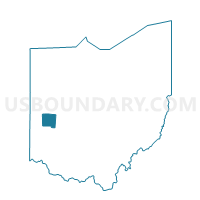
Outline

Summary
| Unique Area Identifier | 650078 |
| Name | PRECINCT ELIZABETH |
| County | Miami County |
| State | Ohio |
| Area (square miles) | 29.88 |
| Land Area (square miles) | 29.84 |
| Water Area (square miles) | 0.04 |
| % of Land Area | 99.88 |
| % of Water Area | 0.12 |
| Latitude of the Internal Point | 40.00631550 |
| Longtitude of the Internal Point | -84.09769030 |
Maps


Graphs
Select a template below for downloading or customizing gragh for PRECINCT ELIZABETH, Miami County, Ohio


Neighbors
Neighoring Voting District (by Name) Neighboring Voting District on the Map
- Voting District JACKSON WEST, Champaign County, OH
- Voting District PIKE 1, Clark County, OH
- PRECINCT BETHEL EAST, Miami County, OH
- PRECINCT BETHEL WEST, Miami County, OH
- PRECINCT LOSTCREEK/CASSTOWN, Miami County, OH
- PRECINCT STAUNTON SOUTH, Miami County, OH
Top 10 Neighboring County Subdivision (by Population) Neighboring County Subdivision on the Map
- Bethel township, Miami County, OH (4,843)
- Pike township, Clark County, OH (3,730)
- Jackson township, Champaign County, OH (2,644)
- Staunton township, Miami County, OH (2,090)
- Lostcreek township, Miami County, OH (1,676)
- Elizabeth township, Miami County, OH (1,648)
Top 10 Neighboring Unified School District (by Population) Neighboring Unified School District on the Map
- Tecumseh Local School District, OH (19,020)
- Graham Local School District, OH (11,965)
- Northwestern Local School District, OH (10,829)
- Miami East Local School District, OH (7,459)
- Bethel Local School District, OH (5,606)
Top 10 Neighboring State Legislative District Lower Chamber (by Population) Neighboring State Legislative District Lower Chamber on the Map
- State House District 78, OH (121,455)
- State House District 79, OH (119,858)
- State House District 84, OH (116,799)
Top 10 Neighboring State Legislative District Upper Chamber (by Population) Neighboring State Legislative District Upper Chamber on the Map
- State Senate District 12, OH (346,477)
- State Senate District 10, OH (343,341)
- State Senate District 5, OH (318,239)
Top 10 Neighboring 111th Congressional District (by Population) Neighboring 111th Congressional District on the Map
- Congressional District 7, OH (683,371)
- Congressional District 8, OH (663,644)
- Congressional District 4, OH (632,771)
Top 10 Neighboring Census Tract (by Population) Neighboring Census Tract on the Map
- Census Tract 102, Champaign County, OH (7,260)
- Census Tract 3801, Miami County, OH (5,802)
- Census Tract 3651.02, Miami County, OH (5,118)
- Census Tract 3901, Miami County, OH (4,919)
- Census Tract 26.01, Clark County, OH (3,818)
- Census Tract 27.01, Clark County, OH (3,173)